
Abingdon Reservoir: what are the risks?
In part two of a personal look at the case for and against a new reservoir near Abingdon, Andy Cooke asks if a 150-billion litre ‘bunded’ reservoir is too risky.
In 2010, a public inquiry into Thames Water’s then proposals found that a 100-billion litre reservoir was unjustifiable – but a 50 billion litre one could be justified. However, Thames Water walked off at that point. They’ve now come back with a 150 billion litre proposal instead.
We’re just throwing numbers around here. Is 50 billion litres particularly small? And is 150 billion litres really mega-sized?
Reservoir size depends on what type it is
There are three main types of reservoirs. The first are repurposed natural lakes, which can be as large as you like – you just have to find a suitable lake. Or loch: the record-holders in the UK are Scottish lochs. These are less disruptive than the more artificial options, for obvious reasons.
The second type of reservoir are the ones we usually think of when we think “reservoirs”: a dam across the end of a valley, which then fills up with water. The record-holder in the England of this type is Kielder Reservoir, with a 1.2km dam holding back about 200 billion litres of water. There’s some risk to these downriver in case of dam failure, and it’s bad news for anyone or anything formerly in the valley, now under the waves.
There’s a distinct lack of mountain valleys near Abingdon, of course, or huge natural lakes. This means SESRO would have to be one of the third type of reservoir – completely artificial and built up. Known as “non-impounding fully bunded” reservoirs, these are made by taking a flat bit of land and wrapping a dam entirely around the site of the reservoir, then filling it up as if with a very big hosepipe.
First, you dig down – a bit. Not too far; you’ll end up damaging aquifers if you do. (You don’t have to dig too deep around here to get to running water.) Mainly you have to build up, with huge clay embankments, hopefully as non-permeable as possible. Leaking out too much water is embarrassing, as well as possibly dangerous. These are the most involved type of reservoir by far to construct and maintain, and usually smaller than the other two types.
How much smaller? Farmoor Reservoir is familiar to many. It consists of two sub-reservoirs of this type, which add up to a total of under 14 billion litres (compared to the average reservoir in the country at 3–4 billion litres). So far, the largest reservoir of this type in the country is the Queen Mother Reservoir in Datchet, at 30.4 billion litres. The dam around that one is no less than 6km long, nearly seven times as long as the one at Blackwater.
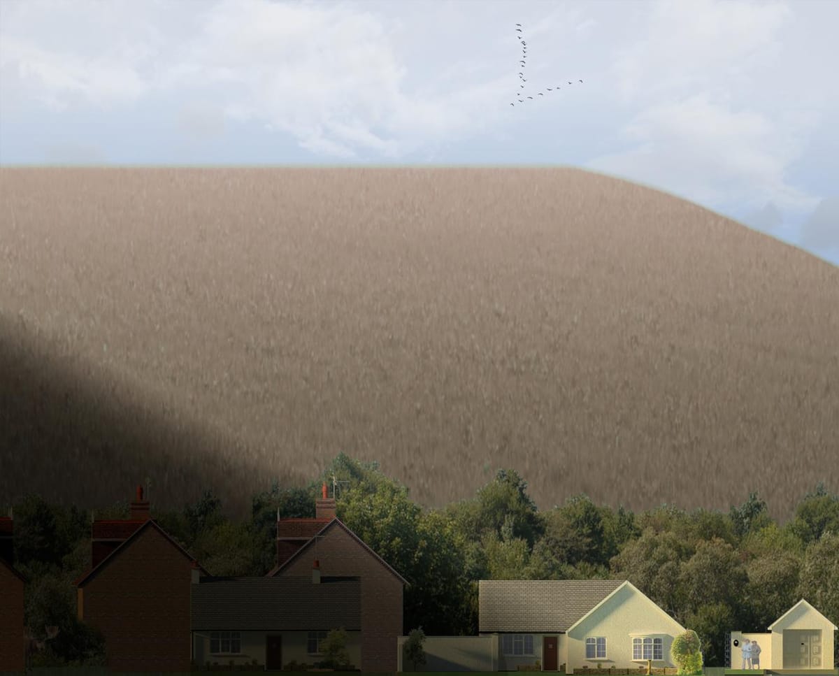
SESRO would have a dam 11km long and up to 25 metres high (comparable to an eight-storey building). It’s much bigger than any fully bunded built-up reservoir we’ve ever seen in this country.
In illustration:

SESRO would hold more water than all South West Water’s reservoirs put together, and two-thirds as much as all Thames Water’s current reservoirs.
The size of a small town?
Size is important. One harsh truth of any construction project is that you can’t just scale everything up and expect it all to be the same. Size has a quality all of its own, and comes with problems all of its own.
When trying to come up with analogies for the scale, I calculated that the weight of a town like Swindon was somewhere between 30 million and 50 million tonnes, including everything in it (buildings, roads, vehicles, people, and the like). A similar calculation suggests that the borough of Manhattan in New York – not the physical island itself, just everything that’s been built onto it – is 125 million tonnes.
The water in SESRO alone comes in at 150 million tonnes. Heavier than Manhattan. Three to five times the weight of Swindon. That’s even before considering the weight of the 11km, eight-storey-high broad clay bank.
In 2017, Thames Water assessed all potential sites in their region for feasibility of supporting reservoirs [Thames Water WRMP19 Resource Options – reservoir feasibility report, July 2017]. They shortlisted half a dozen or so, and then explored just how large a reservoir they could squeeze onto each site. They fell in love with the Abingdon site because they could squeeze a full 150 billion litres onto it. They promptly pitched for as large as they could get – an impulse we all share. When someone else is paying, anyway. And they won’t “waste” the site on anything smaller.
Floods, sweat, and tears
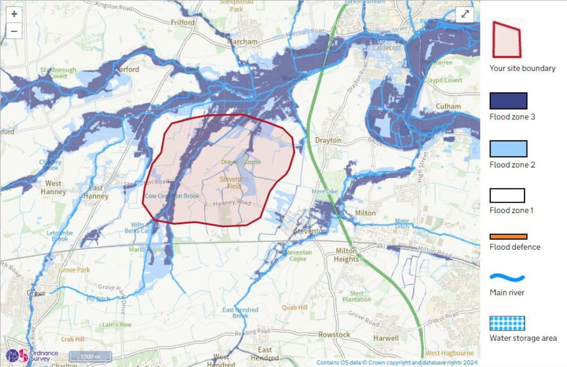
The drawback was that as soon as their designs went past 50 billion litres, the sprawling size over the floodplain meant that the flood risk turned to “red” on their metrics, as it was impossible to compensate for the floodplain loss on site. This may be linked to the public enquiry giving 50 billion litres (already nearly twice the size of the record-holding Queen Mother reservoir) as the top limit to what they’d consider justifiable.
Given that the flooding situation in the area has only got worse over time – we’ve suffered multiple serious floods in the area recently – you might think this would be a show-stopper. We’ve already been told that we need more floodplain provision south of Marcham, not less.
Beyond the “fluvial flooding” from the water courses and flood zone displacement shown, there’s also groundwater flooding, as the underground aquifers get diverted. This alone would increase groundwater flooding by “up to a metre” according to Thames Water’s modelling.
We have yet to see any modelling for the fluvial flooding, or any designs for flood mitigation.
Disruption and dam breaks and fogs, oh my
Obviously, building something on this scale takes a lot of digging and lorry movements, with associated emissions. In huge quantities. Hundreds of heavy vehicles every day down country lanes, plus all the diggers and earth-movers. Perhaps Thames Water will use electric earth-moving vehicles, but suitable ones don’t yet exist. The Hanney Road will be buried under the reservoir, which will loom over nearby houses.
In operation, it’s been found that reservoirs end up with significant greenhouse gas emissions – from decaying plant matter that gets exposed during drawdowns (see these two studies: 1, 2). As well as that, plus algal blooms and so forth, we have the “Intrusive Non-Native Species” [INNS] threat. Aggressive non-native species are already intruding into the lower Thames and being fought back. We do not want them transported to a big reservoir in the upper Thames and released into the river, and neither do any regulatory bodies.
Thames Water noted in their Gate 1 submission to RAPID that it may be necessary to remove all terrestrial recreational activities (“The full removal of all terrestrial recreational activities or aquatic recreational activities means the site would be considered a ‘low risk’ “) to keep the risk of INNS low enough. Something of this scale is hard to properly police. They hadn’t solved it as of Gate 2. To be fair, they do say up front: “The details set out in the Gate 2 documents are still at a formative stage and consideration should be given to that when reviewing the proposals. They are for the purposes of allocating further funding not seeking permission.” They say they think it unlikely that they’ll exclude recreational access purely on the basis of INNS risk management requirement. (The cynic in me thinks they’ll continue to promise access at this stage; after it’s approved and begins construction, who knows?)
All inland bodies of water are susceptible to having their own microclimate. Unlike most, this won’t be in a valley, it’ll be raised up above the surrounding area, adding a peculiar element to it all – namely that aspects of the microclimate will spread out rather than staying put. Most of this won’t be an issue, but there is one that could be: fog. Lakes can cause fogs from cold air passing over warmer water (“evaporation fogs”) in autumn and winter, as can the cooling of the air close to the surface in winter (“radiation fogs”) and moist warm air passing over colder water in summer (“advection fogs”).
As it’s raised up, the fog, heavier than the air around, would roll down the slopes. Given that these slopes are right next to the A34 in one direction and the country’s main east-west railway line in another direction, such fogs could be inconvenient or even dangerous.
But beyond the disruption, environmental damage, and potential fogs over the A34 and mainline railway, one thing should have leapt to mind when you saw the picture above: what happens if that dam springs a leak?
Alarmism?
Obviously a weight of water heavier than Manhattan coming through that all-the-way-around twenty-five metre high 11-kilometre-long clay dam could be disastrous. Surely that’s not possible, though?
Unfortunately, as we’ve seen recently at Toddbrook Reservoir, and many times around the world, dam break is definitely something to consider. The EA have a report covering it, noting soberly:
“News items in New Civil Engineer with headings such as ‘Dam emergency rings checking alarm bells’ (23 January 2003) and ‘Unstable dam assessed after 10 years’ neglect’ (30 January 2003) show that near misses continue to occur. It was reported in New Civil Engineer (21 November 2002) that “reservoir engineers told NCE last week that as many as four dams and reservoirs could be at risk from bursting every year".
“If asked to cite failures of British dams, most engineers in the reservoir industry would be able to quote Dale Dyke, Bilberry and Dolgarrog, together with recent serious incidents such as Ulley, but many would struggle to name more of the several hundred incidents that have occurred. The lack of knowledge of dam incidents can give rise to misplaced optimism with respect to the long-term deterioration of dams. This report aims to counter this by providing a broad perspective on the range of incidents that have arisen in the past and can arise again.”
It's not just East Hanney, in the shadow of the dam, or Steventon or Drayton that would be worried. There’s the mainline railway, running only a few hundred metres from the edge of the dam. But any breach towards the railway could actually be the least worst scenario. Yes, any passing trains would have a very bad day, but there’s a gentle upwards slope in that direction, as well as the lowest population density in the area.
Looking in other directions, you notice that the town of Abingdon (population 38,000), across the A34, is downhill from SESRO. The edge of Abingdon is only about 1,200 metres from the closest (but highest) side of the reservoir. The River Ock flows down towards the town, providing a helpful route for water from a dam breach. Whilst we’d expect the water velocity to get dissipated to a significant extent as it rolls over the ground, there’s a truly colossal volume of water involved.
So, yes, this does cause considerable concern, and we’d really like proper reassurance that there are no real dangers. We’ve had an independent dam and reservoir expert report that he is genuinely concerned about this, and he’s even emphasized that due to its strategic nature and unparalleled scale, it could feasibly be a terrorism target for a vehicle-based bomb: a report commissioned for GARD says “a terrorist attack, leading to dam breach and a flood wave downstream, would need to be considered as a dam break risk”.
These concerns have been brought to Thames Water’s notice. In their Environmental Impact Appraisal, though, they actually asked to “scope out” (ignore) dam breaks, as they’d design it so well this wouldn’t be a problem. Fortunately, there were a slew of objections to this request (including by the District Council, and the County Council, amongst others) and the EA agreed with the objectors. Thames Water were therefore obliged to scope it right back in again. Less fortunately, they got their own way in “scoping out” the potential terrorism threat, based on their pledge that they’d surround the site by fences, CCTV, and guards – a site the size of Abingdon itself and promising a variety of recreational facilities.
When issues do arise, you have to pump the water out as quickly as you can to minimise the dam breach risks and potential flooding. The reservoir will need an “emergency drawdown” plan, at the rate of 76 cubic metres per second – triple the average flow rate of the Thames at this point along the river, so it might just end up sharing the flood risk downstream. Even at that rate of blasting water out into the Thames, this thing is so big it would take three weeks to draw down.
Flood plans? We don’t need no stinking flood plans!
With all of that water, the potential for dam breaches, and so forth, it’s compulsory to have a flood plan (involving evacuation of everyone downhill from a dam) for a reservoir. Given the scale, and that every direction is downhill from a fully-bunded reservoir, I’m very interested in seeing it – after all, my family will be one of those who could need it.
This sort of flood plan would be triggered if faults were detected before they caused catastrophic failure – which is (fortunately) more likely than the disaster scenarios above. Whilst the emergency drawdown was going on, they’d need to evacuate everyone in the risk area, as they did for the town of Whaley Bridge when the Toddbrook dam issue occurred in 2019. Here, that would include at least 10,000 of the people of Abingdon, as mentioned above. The people of Whaley Bridge had to spend 6 days evacuated; for the residents of Abingdon, this might be up to three weeks. Might we also see the A34 closed and maybe even the main railway line closed for the duration?
Thames Water state they don’t intend to provide this plan until the last moment that’s compelled by regulation. Specifically – after the reservoir is built, but before it is filled with water. Which is a bit late in the day to find out whether it’s even really feasible, or how difficult and expensive things would be.
Supersize something, and you supersize the problems
Hopefully you’ll have picked up that concerns are real. It’s not about concern over views, or losing pretty countryside. Given the scale of this mega-reservoir, people are justifiably concerned about flooding (which could make many houses uninsurable), disruption, subsidence (including to the arterial A34), local fog issues, dam break threats, and so forth.
All of these are inextricably linked with the unparalleled scale of it. Put in a reservoir the size of the existing record holder in Datchet, and most of us would be fine with it. Even though it’d still be a very large reservoir, it wouldn’t be a record-holding mega-reservoir: those risks would diminish a long way, or even go away altogether.
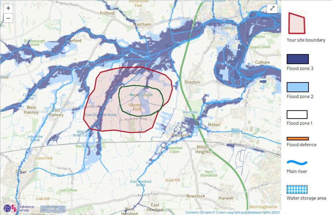
Thames Water could have gone ahead with such a reservoir after the last public inquiry. Above, I’ve overlayed the 30bn litre reservoir plan (green perimeter) from the 2017 Thames Water report, onto the site for the big SESRO proposal (red perimeter). You’ll notice all the roads remain intact, the reservoir sprawls much less over the worst of the floodplain (zone 3), and it’s much further from looming over most houses. There is much less water to loom over Abingdon (not to mention the villages around it) – in fact, as it would be very much below ground, no real “looming” at all. Most of those dam-break scenarios go away, which means the area for evacuation in case of drawdown is much less, and any drawdown is far less protracted.
Water load of problems
Reservoirs have challenges in operation. You don’t just dig a big hole (or build up big embankments) and wander off. And the bigger the reservoir, the bigger the challenges.
The Thames, being so water-stressed, has a “hands-off flow” level, below which you can’t pull water out of it. In essence, you’ll only be able to pull water into the reservoir in winter – which is when we have the worst of the sewage overflows that we’ve been suffering. (There’s a sewage overflow outlet a short distance upstream from the proposed intake that discharged for over 2000 hours in 2023. That’s the equivalent of 87 continuous days.) There’s also sewage treatment plants discharging into the river from Swindon and Oxford.
When the river’s flowing high, even if you don’t get any sewage, it carries a lot of silt. This means, paradoxically, after heavy rains (when we’d expect reservoirs to be filling up at maximum rates), they can’t pull water into the reservoirs – as I found out when asking why Farmoor Reservoir was so low after a rainy winter.
Keeping it filled will be a challenge, but filling it up in the first place would be very challenging. If you luck out with a winter without heavy rains or sewage overflows. you might fill it in about two full years. Once you’ve got all that water, you’ve got to keep it in good condition: Farmoor Reservoir can suffer from poor water quality and even big blooms of algae (to be fair, all reservoirs can suffer from this). This is due to stagnant water, so Farmoor tries to minimize this by regularly pulling water in and discharging it out to the Thames. As it’s allowed to do this even in summer (because it’s so much smaller than SESRO), it can avoid the most sewage-laden flows and silty flows, and use this in-and-out flow to try to keep a handle on not getting too stagnant.
SESRO can’t do that. It’s too big. Stagnant water and algal blooms will be a constant headache, as will getting enough water in at the right quality and times. Thames Water have muttered about getting an aeration system installed, but this needs a bit more explaining and would end up contributing to significant running costs.
You also have to prevent anything getting into the reservoir to make it dangerous. In the week before writing, I’ve seen news stories including Guernsey’s main reservoir becoming unusable due to pesticide getting into it, and South West Water apologising after a parasite outbreak in a reservoir. Both of these reservoirs were much smaller (1 million litres and 0.3 million litres respectively), so flushing them out, cleaning, and refilling is more straightforward. When you’ve got a strategic mega-reservoir, you’ve got all your eggs in one basket.
The standpoint of putting up lots of security and refusing access to the public is probably the most sensible thing to do by far, and even then, you’re still running some risk. It would be nice if Thames Water were upfront about this rather than promising lots of recreational access. It’s supposed to be a regional strategic water reserve, after all; any recreational activity would be a pure bonus.
Weighing up the risks
So – in conditions when SESRO might be needed, how much water would be in it (of sufficient quality to use), and how much could we actually use?
A lengthy drought would cause it to run down from whatever level it’s at, and there’s a minimum emergency level in a reservoir before what’s left is pretty unusable. Thames Water are proposing a much lower emergency level for SESRO – is that feasible? Why even build the largest reservoir of its type, and have it totally dependent on the most water-stressed major river in the country?
It could make sense if we could turn on more water in the Thames like opening a tap. Which we could if a Severn–Thames Transfer was online. However, if STT was available, we wouldn’t need SESRO; it’d be just a brief detour for the water. We could use it to hold onto a chunk of the STT water – but then, we could build any reservoir for this anywhere if we had a National Water Grid. All the reservoirs we do have in the various regions are already enough if we can move water around the country properly.
This is why the NIC plan said that consideration of any reservoirs (in and among desalination and water re-use schemes) should come after that of full implementation of the transfer network, to fill in gaps only where needed.
So - what’s wrong with that STT pipeline option? Too expensive? Too slow? Too difficult? Not effective enough?
Nope. It’s a fraction of the price. Much quicker to build. We have much more recent expertise in pipelines. Much less disruptive. None of these problems above. And you could scale up or down in the planning and even construction phase if you learn you need less or more.
My cynical feeling is that the real issue with STT is simply that it would, as mentioned just above, make SESRO redundant. You don’t need both of them: Thames Water admit that themselves by leaving STT out of their latest plans. There are even rumblings from those even more cynical than me that the commercial value (as water companies have what is called a “Regulated Asset Base” that governs much of their value and what they can charge) is crucial. STT is certainly less valuable to the company, and much less commercially attractive.
Summary
With all of the difficulties of which I’m now aware, I almost have sympathy for water companies. Well, I would, if they focused more on solving these difficulties, and less on dividends, debt-swapping, and their own commercial interests. I have a great deal of sympathy for those working at Thames Water – just not necessarily the owners.
The proposed reservoir is not only big, but unparalleled in scale for the UK and even Europe. (I’ve heard a rumour that there may be one of similar scale somewhere else in the world, but I can’t find it: let me know if you can!) How long would construction take, and how expensive would it be? We don’t really know, but the track record of megaprojects suggests it’s likely to be more expensive and take much longer than originally quoted.
It is possible to bring in megaprojects on time and on budget, but there are things you should do. These rarely get looked at in advance and by media commentators. But we’ll look at them next time – and we should. Because through our water bills, we’ll be paying.