Culham Town: the future of housing in Oxfordshire?
If there's anyone who thinks housing in Oxfordshire has been planned optimally and sensibly in recent years, we have yet to meet them.
"Planned" at all might be generous. Houses have been ladled onto Wantage and Grove, Witney and Carterton, each one in a rail desert and situated on a congested road. Oxford's Green Belt has been nibbled at here and there, without any coherent appraisal of how a boundary drawn up in 1975 is still relevant today.
Oxford City Council is eking out every spare plot it can find - garages, depots, recreation grounds - while the debate about city centre offices vs housing rumbles on. New estates are knocked up without the most basic of infrastructure: Barton Park still doesn't have a safe pedestrian route to Headington and the city; cycling from Oxford North is reliant on the piecemeal provision of Woodstock Road; and let's not mention the ongoing farce of junctions on Bicester's ring road.
Houses are being built, slowly. But if you were planning an Oxfordshire fit for the 21st century, you wouldn't start from here.
A chance to get it right?
Enter the most promising development site in Oxfordshire for decades.
It's officially known as "STRAT9 Land adjacent to Culham Science Centre". Developers are modishly styling it as "Culham Science Village". But we're going to call it Culham Town, because that's what it is: a town-size development in the space between Culham village and Culham Science Centre, between Oxford and Didcot.
If you were planning an Oxfordshire fit for the 21st century, this would be exactly where you’d start. "Science Vale" employment on site, reducing the need for out-commuting. An existing railway station with a service already slotted into the timetable, ready to speed residents to Oxford or London without expensive new infrastructure. Cycling distance from Abingdon, Didcot, Milton Park, and Oxford's science parks. A natural landscape bookended by the Thames and Nuneham Park, but not so precious as to rule out development.
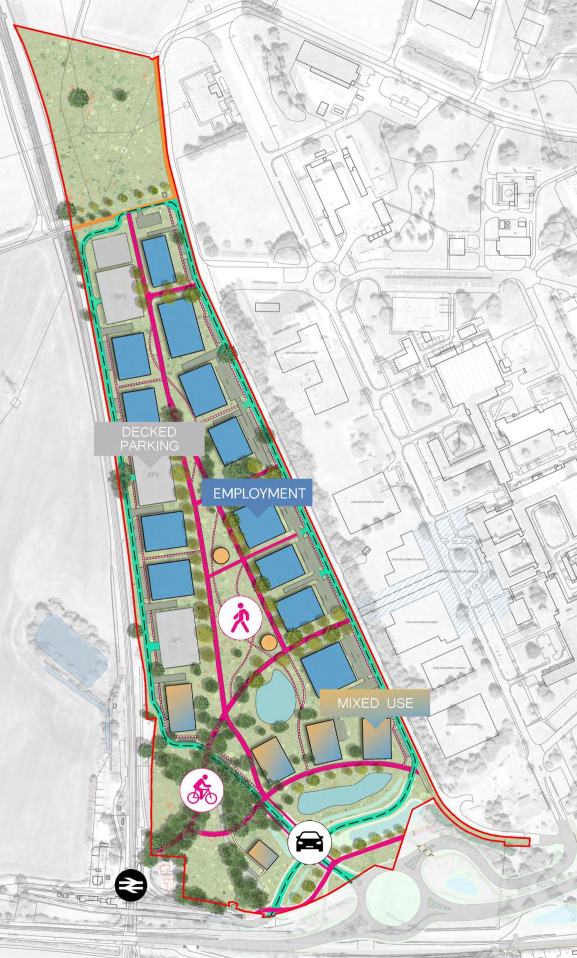
The first piece of this jigsaw is about to be set down. Developers CEG have lodged an outline planning application for "Culham Site No 1", the employment component. This entails demolishing the low-grade buildings currently to the east of the railway line, and replacing them with:
- up to 115,000sq.m of employment floorspace
- up to 2,500sq.m of hotel floorspace (aka 100 hotel bedrooms)
- up to 600sq.m of retail floorspace
- up to 500sq.m of health club / gym floorspace
- up to 500sq.m of creche / children's nursery floorspace
- up to 800sq.m of restaurant / public house floorspace
- landscape and associated infrastructure

It isn’t revolutionary, and shouldn't be controversial. It's essentially reconfiguring existing employment land to the trends of 2024, with the ubiquitous "lab space" in England's biotech/space answer to Silicon Valley. There will be concerns over building height, car and bike access, and rightly so: but we don't expect this phase to excite many passions.
What is tentatively sketched out for the western side of the railway line, however, deserves to.
Right size, right time?
3,500 homes. Two primary schools, one secondary. The numbers put it squarely in a bracket that Oxfordshire does well: small market towns.
Chipping Norton and Faringdon each have a population of 6,000 or so. Wallingford, Henley and Thame are around 11,000. All five are towns that you'd expect to star in the Sunday Times' annual Best Places to Live list. Culham will slot in at the top end. It's an undeniable sweetspot: big enough for the facilities you need in everyday life, small enough to escape the deadening effect of relief roads, endless roundabouts, big-box warehouses and, however you define it, "sprawl".
Oxfordshire's small towns, however, miss out on rail connections. Only Henley and little Charlbury, a minnow at 3,000 residents, are lucky enough to have stations. They are two of Oxfordshire's most sought-after locations. Culham could join a very select club.
The best laid plans?
The challenge for South Oxfordshire planners is to ensure the new Culham is a town worthy of the name - not just a dormitory estate transplanted into a twist of the Thames. A generic 1990s-style development would not only fail to make the most of this unique site, it would bake in car dependency that would exacerbate congestion on roads that are already over capacity. If you've ever queued on the A34 or at Abingdon Bridge, you’ll understand how 3,500 extra cars could become a daily nightmare.
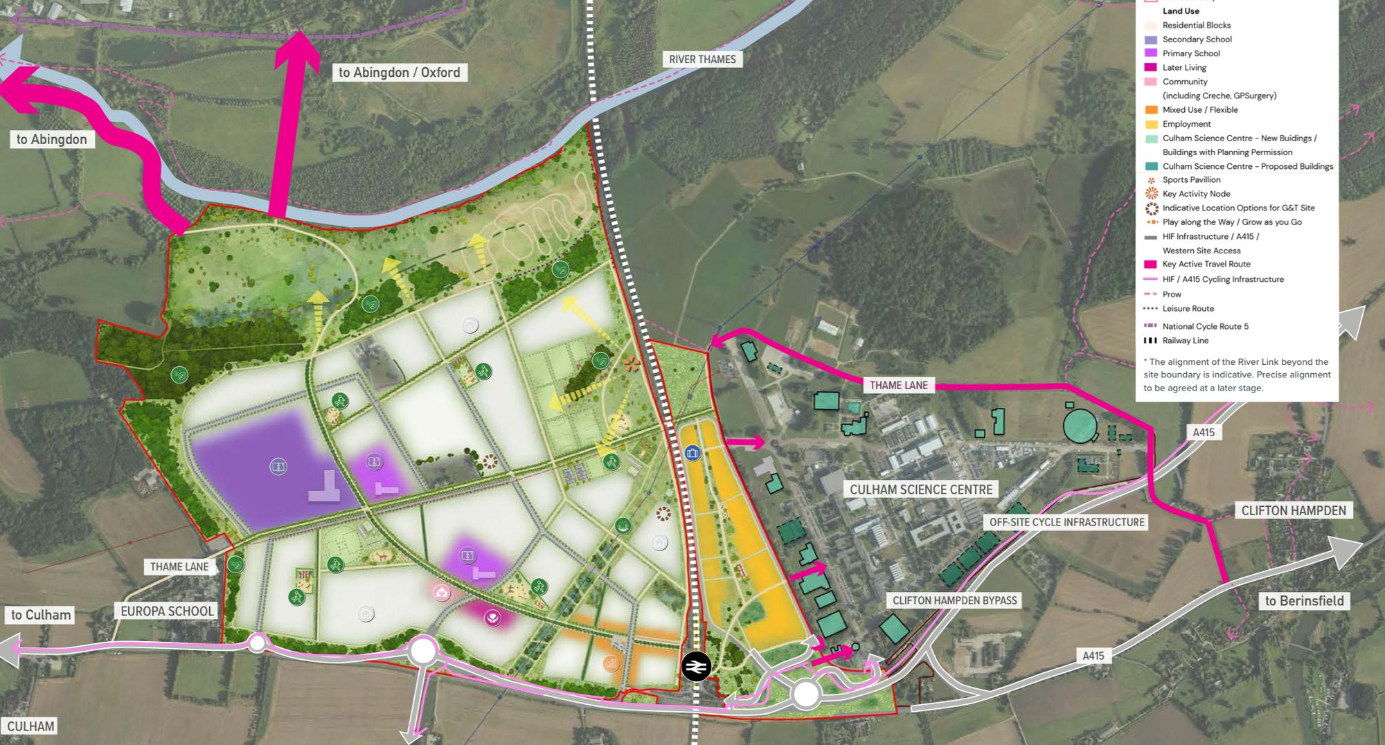
The masterplan for Culham Town itself is 100 pages of aspirations, concept drawings and artists' impressions. (You can read it by opening the planning application, then scrolling down to 'Supporting Documentation' and in turn 'Framework Masterplan'.)
It's tentatively ambitious, if that’s not an oxymoron. The town will be oriented around a pedestrian boulevard and cycleway called the "River Link", a gently curving throughway from Culham station to a new cycle bridge over the Thames to Abingdon. (No more squeezing over the narrow A415 Causeway.) The street design is thoroughly on point with pedestrians, cyclists and buses given pride of place: other developers (and, dare we say, Oxfordshire County Council) could learn a lot.
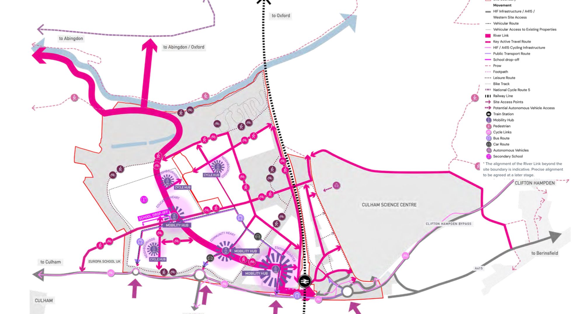
Residential areas are set out in "quarters", each with a distinct density and architectural style. There is some notion of a town centre/retail hub, positioned next to Culham station in the "Station Quarter" - and here we have qualms. The optimum position of the town centre could be endlessly debated (at the geographical centre of the town? close to Culham village?), but this urban design principle stands out:
The area will be characterised by contemporary taller forms occupying entire plots to back of pavement edge.
It's illustrated by examples from a new Cambridge suburb:
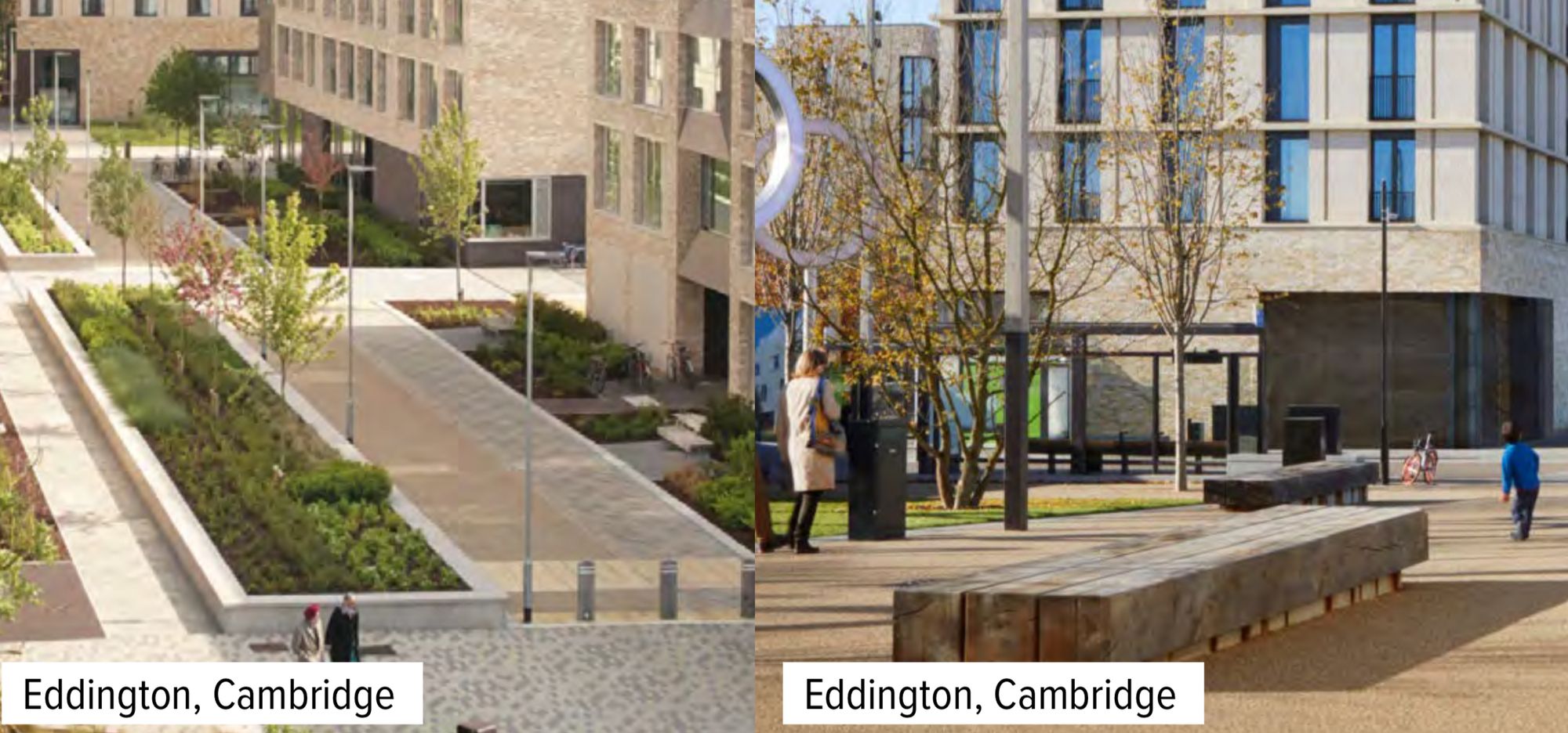
Throughout the document, there are examples from Cambridge, Uxbridge, France and Germany - but none from Oxfordshire. Your Clarion writers are no Jonathan Meades or Rowan Moore, but we are genuinely puzzled why South Oxfordshire District Council would pass up the coveted archetype of an Oxfordshire market town centre for something that looks like Central Milton Keynes 2.0.
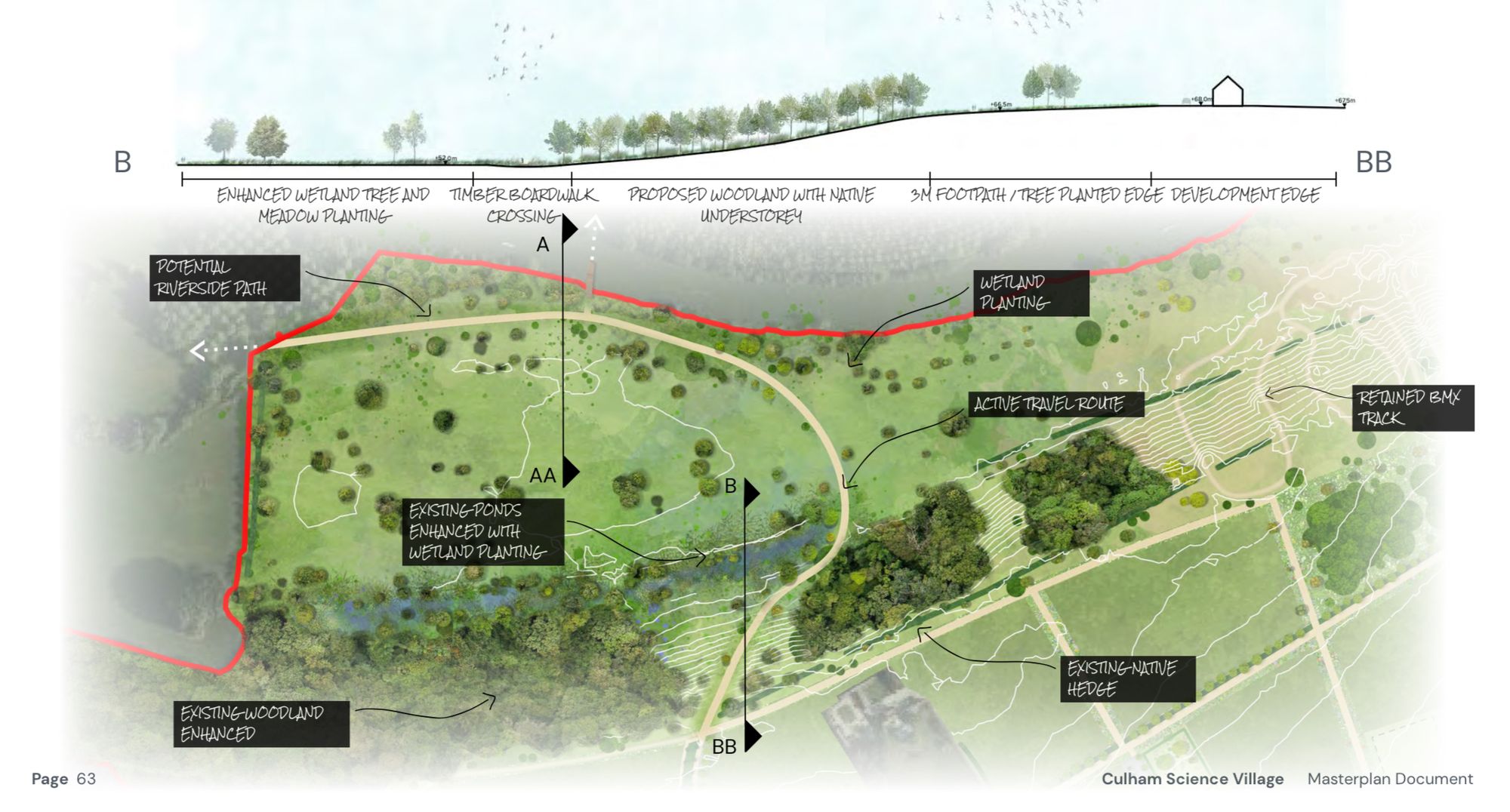
Our other reservation is the role of the River Thames in the development. From Lechlade to Henley and beyond, every town makes the most of its location on England's Royal River. The Culham masterplan doesn't. The Thames is treated with kid gloves to pass Environment Agency approval at minimal cost, without any attempt at a genuine waterfront. The section title is "Responding to the River Thames Floodplain", as if the Thames is a problem to solve, not a peerless natural asset.
It isn't an easy question to answer: a steep bank to the riverside (currently used for a motocross track) effectively rules out built development, and there's a rightfully beloved Site of Special Scientific Interest. Still, we believe Culham Town's new residents deserve everyday opportunities to cherish and enjoy their river, rather than treating it as a distant nature reserve.
No consultation for the residential section has even been announced, let alone an outline planning application. For now, the masterplan document is merely adding colour to the commercial plans east of the railway. Detailed planning and construction could take "decades".
Of planning policy and elephants
There are two elephants in this particular room.

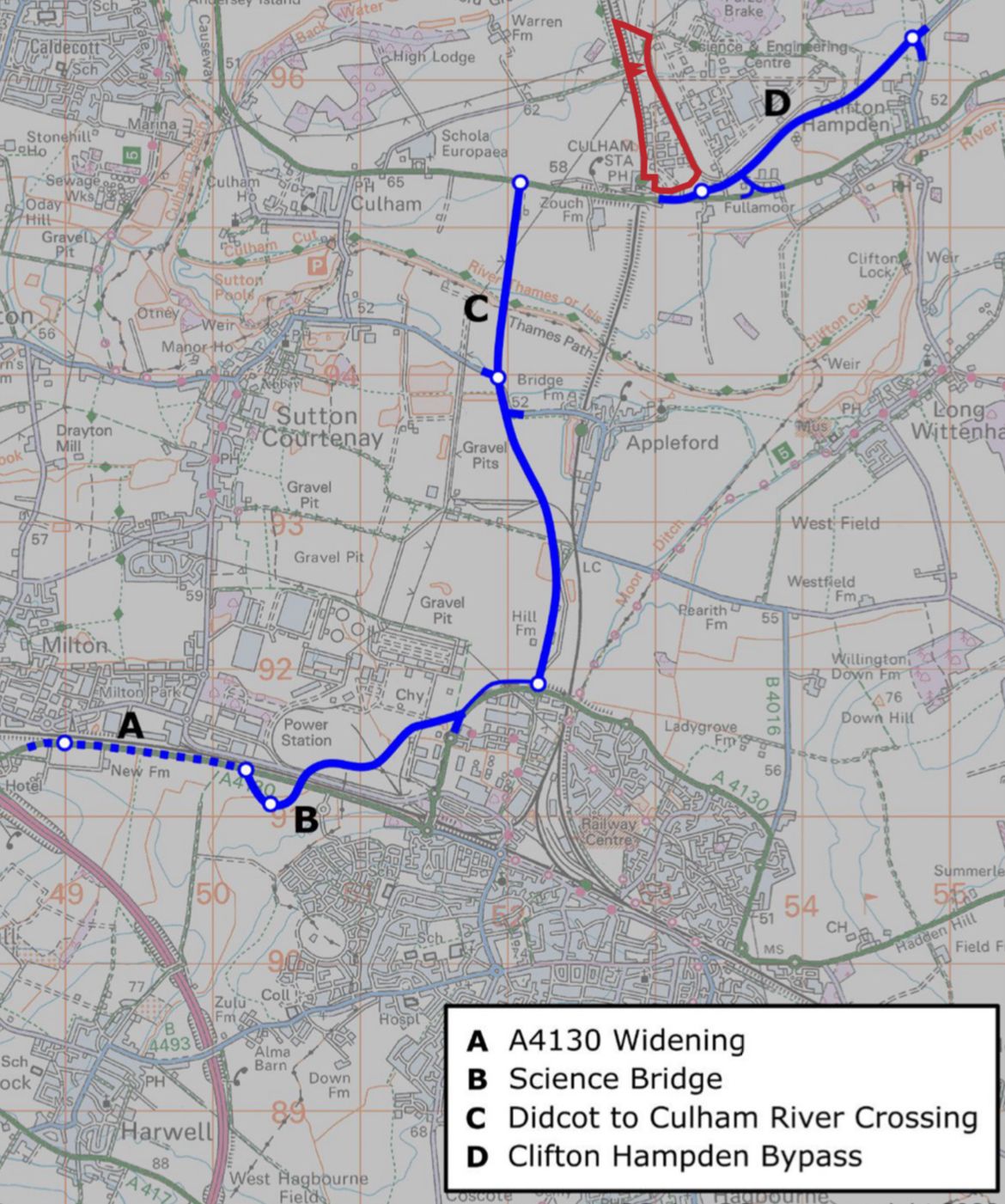
One is the Didcot-to-Culham relief road, known as HIF1 after the Housing Infrastructure Fund that’s paying for it - or not. The plans were knocked back by Oxfordshire County Council's planning committee (which is independent of the LibDem/Green administration), then "called in" by previous Secretary of State Michael Gove, and put through a planning inspector's examination. The outcome of this palaver is as yet unknown. If the road is built, that in theory makes a Culham development more likely to get planning permission. Refusing the road could perhaps force a more imaginative development, one reliant on trains, walking and cycling - but would that be a leap too far for planners?
The second elephant is the change of Government. Labour has pledged to "get Britain building again". Reform of the planning system seems inevitable. But to what end?
Your Clarion scribes could happily spend hours deep in the weeds of planning policy analysis. We'll spare our readers that doubtful pleasure for now, but one issue is crucial to Culham. Broadly speaking, English planning law is "discretionary": a council can freely choose whether to approve a development. (And a developer can freely choose to unleash squadrons of lawyers if the decision goes against them.)
There's widespread speculation that Labour could make the system more "rules-based". This would set out a national (or regional?) list of development rules: if a proposal meets those rules, it gets approved. That way, everyone knows what they're working to, and the squadrons of lawyers are out of a job. It's an alluring idea - if the rules are up to scratch.
But what if a Government determined to "get Britain building" sets out lax rules that would allow Culham Town to be identikit car-dependent suburbia without an urbs to fall back on? A publicly quoted developer will build the cheapest infrastructure for the maximum sale price. In Oxford's overheated housing market, there's no incentive to spend more on building better.
The local view
The optimistic view of Culham Town as a sustainable, right-sized development is not shared by everyone. Culham Parish Council, together with CPRE Oxfordshire, have been campaigning under the banner of "Save Culham Green Belt" since the site was first proposed for South Oxfordshire's Local Plan six years ago.
They say "Culham’s precious Green Belt provides protection for the countryside between Oxford and Abingdon and is primarily used for agricultural and recreational activities. The development of this area threatens not only the countryside but a statutory protected Site of Special Scientific Interest (SSSI), a woodland called Culham Brake, home to a rare and threatened plant called the ‘Summer Snowflake’."
Local councillor Nathan Ley recognised the conflicting pressures in a tweet. "I will certainly take my time and avoid any knee jerk comments - after all, we have a massive housing crisis with multiple generations betrayed, so we have to view it through that lens."
What are you doing this weekend?
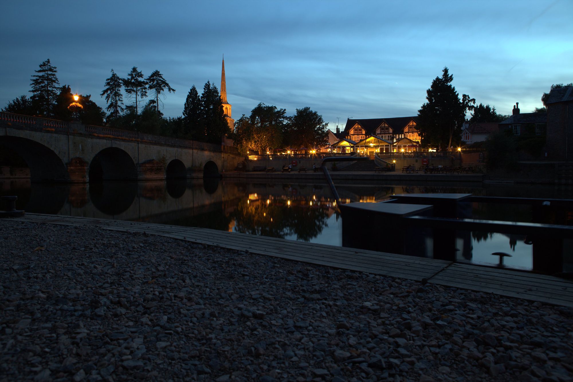
Take a trip out of Oxford. Get the bus to Chipping Norton, Wallingford or Faringdon. Catch the train to Henley or Charlbury (where the free Riverside Festival is this weekend, should you need an excuse). Walk around. Take photos. Find the park, the playground, the pubs; the church, the community centre, the cafes. Check out the event posters outside the town hall. Sketch yourself a map. See how a small town fits together.
Now call up Google Street View and tour a modern estate: Kingsmere in Bicester, Shilton Park in Carterton, Hanwell Fields and Hanwell Chase in Banbury. What’s missing? Picture yourself as a new resident. What would you import from Wallingford, Chipping Norton or Henley?
The space between the two is the opportunity - and the challenge - for Culham Town.
